File:20040514 large hail 5.25".jpg
Jump to navigation
Jump to search

Size of this preview: 548 × 600 pixels. Other resolutions: 219 × 240 pixels | 439 × 480 pixels | 659 × 721 pixels.
Original file (659 × 721 pixels, file size: 60 KB, MIME type: image/jpeg)
Captions
Captions
Add a one-line explanation of what this file represents
Summary[edit]
| Description |
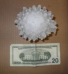
English: A large hailstone, approximately 133 mm (5 1/4 inches) in diameter, that fell in Harper, Kansas on May 14, 2004.
Français : Un grêlon de 133 mm de diamètre, tombé à Harper, dans le Kansas le 14 mai 2004. |
|||
| Date | ||||
| Source | http://www.crh.noaa.gov/ict/scripts/viewimage.php?STORY_NUMBER=2004051418&IMG_NUM=16&loc=local | |||
| Author | National Weather Service - Wichita, Kansas | |||
| Permission (Reusing this file) |
|
| Object location | | View this and other nearby images on: OpenStreetMap |
|---|
Licensing[edit]
This image is in the public domain because it contains materials that originally came from the U.S. National Oceanic and Atmospheric Administration, taken or made as part of an employee's official duties.
|

|
This image has been assessed under the valued image criteria and is considered the most valued image on Commons within the scope: Hailstone. You can see its nomination here. |
File history
Click on a date/time to view the file as it appeared at that time.
| Date/Time | Thumbnail | Dimensions | User | Comment | |
|---|---|---|---|---|---|
| current | 11:08, 7 September 2009 | | 659 × 721 (60 KB) | Ks0stm (talk | contribs) | {{Information |Description={{en|1=A large hailstone, approximately 5 1/4 inches in diameter, that fell in Harper, Kansas on May 14, 2004}} |Source=http://www.crh.noaa.gov/ict/scripts/viewimage.php?STORY_NUMBER=2004051418&IMG_NUM=16&loc=local |Author=Natio |
You cannot overwrite this file.
File usage on Commons
The following 5 pages use this file:
File usage on other wikis
The following other wikis use this file:
- Usage on bg.wikipedia.org
- Usage on da.wikipedia.org
- Usage on el.wikipedia.org
- Usage on en.wikipedia.org
- Usage on en.wikiversity.org
- Usage on kbp.wikipedia.org
- Usage on lv.wikipedia.org
- Usage on mk.wikipedia.org
- Usage on pl.wiktionary.org
- Usage on pt.wikipedia.org
- Usage on ta.wiktionary.org